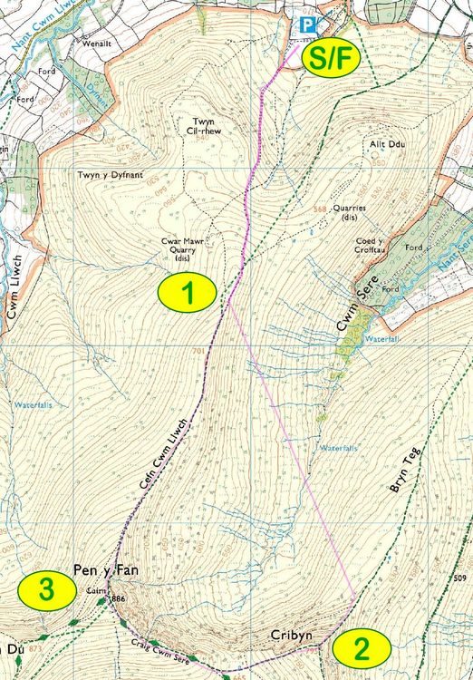
There is no set or marked route, but runners must register their race number with each of the following checkpoints:
Start/Finish field above Cwm Gwdi Camp Car Park - SO 0229 246
Checkpoint 1 on the ridge of Cefn Cwm Llwch - SO 0188 2326
Checkpoint 2 Cribyn Summit - SO 0237 2131
Checkpoint 3 Pen-Y-Fan Summit - SO 0120 2158
Lleoliad
Cwm Gwdi Camp, Brecon Beacons (GR SO 024247)
Active travel: More than 1 hour walk from Brecon along single track roads (not recommended). 30 minute cycle from Brecon, facilities for storing bikes.
Public transport: None (nearest bus stop more than 1 hour walk, no local train station).
Car: We strongly encourage carsharing (see website for help finding liftshares). The carpark is small.
Gwybodaeth diogelwch
General AreaSignificant fell and mountain and/or less accessible or more remote areas | 1 | 2 | 3 | 4 | 5 |
HeightSome up to approx 3,000 ft (900m) | 1 | 2 | 3 | 4 | 5 |
TerrainMostly very rough tracks and/or off track with difficult underfoot sections (e.g. bogs, tussocks, boulders) or steep ascents/descents | 1 | 2 | 3 | 4 | 5 |
Exposure (drops) and hazards on or near routeSome exposure, possibly occasionally severe, and/or increased terrain risk (see left) | 1 | 2 | 3 | 4 | 5 |
Navigation skills requiredAdvanced: no waymarking, and runners must be confident in self navigating over challenging routes and in low visibility | 1 | 2 | 3 | 4 | 5 |
Mountain skills requiredCompetent: suitable only for skilled movers with increased problem solving and self-reliance required | 1 | 2 | 3 | 4 | 5 |
Escape routesSome escape routes but a retiring or injured runner would face difficulty in some sections | 1 | 2 | 3 | 4 | 5 |
Season time and effect of weatherConditions could be challenging and/or route may be prone to sudden weather changes; effect may be significant | 1 | 2 | 3 | 4 | 5 |
Results
Enter
£7 Fabian 4 - no EOD.
Enter onlineTrefnydd
Simon Darke
darkesimon1@gmail.comWedi'i yswirio gan WFRA